David Streit, Commodity Weather Group forecaster, discusses the NOAA's Atlantic hurricane forecast with Bloomberg's Vonnie Quinn and Shery Ahn on "Bloomberg Markets" August 11, 2016
Atlantic hurricane season still expected to be strongest since 2012 | National Oceanic and Atmospheric Administration: "August 11, 2016 In its updated 2016 Atlantic Hurricane Season Outlook, NOAA calls for a higher likelihood of a near-normal or above-normal season, and decreases the chance of a below-normal season to only 15 percent, from the initial outlook issued in May. The season is still expected to be the most active since 2012 ..."
2016 Updated Atlantic Hurricane Season Outlook Summary (source: NOAA, 11 Aug 2016):
a. Predicted Activity
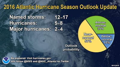
NOAA's updated 2016 Atlantic Hurricane Season Outlook indicates an 85% chance that season will either be near-normal or above-normal. The outlook calls for a 50% chance of a near-season, a 35% chance of an above-normal season, and only a 15% chance of a below-normal season. See NOAA definitions of above-, near-, and below-normal seasons. The Atlantic hurricane region includes the North Atlantic Ocean, Caribbean Sea, and Gulf of Mexico.
Compared to the pre-season outlook issued 27 May, the probability of either a near-normal or above-normal season has increased to 85% (compared to 75% in May), and the probability of a below-normal season has decreased to 15% (from 25% in May). The season is still expected to be the strongest since 2012.
This is a more challenging hurricane season outlook than most because it is difficult to determine whether there will be reinforcing or competing climate influences on tropical storm development. The outlook calls for a 70% probability for each of the following ranges of activity during the 2016 hurricane season:
- 12-17 Named Storms, which includes Alex in January
- 5-8 Hurricanes, which includes Alex in January
- 2-4 Major Hurricanes
- Accumulated Cyclone Energy (ACE) range of 85%-150% of the median.
During 1981-2010, Atlantic hurricane seasons averaged 12 named storms, 6 hurricanes, 3 major hurricanes, and 92.4% of the median ACE.
To date, the 2016 Atlantic hurricane season has produced five named storms, with two being hurricanes. Therefore, for the remainder of the season, we expect (with 70% probability for each range) an additional 7-12 named storms, of which 3-6 are expected to become hurricanes and 2-4 of those are expected to become major hurricanes.
b. Reasoning behind the updated outlook
The strength of the hurricane season is largely controlled by conditions and activity within the Main Development Region (MDR, which spans the Caribbean Sea and tropical Atlantic Ocean between 9°N-21.5°N; Goldenberg et al. 2001). This year, although competing factors are still likely within the MDR during the peak months (August-October) of the hurricane season, overall conditions within the MDR are now expected to favor a more active season than was predicted in May. However, there remains considerable uncertainty regarding when La Niña will develop and how strong it will become, which leads to uncertainty as to whether the Atlantic hurricane season will be near-normal or above normal.
The main factors that are conducive to a more active season now compared to the May outlook include 1) the disappearance of El Niño's suppressing influence on Atlantic hurricanes, 2) weaker vertical wind shear across the central MDR, 3) somewhat weaker trade winds across portions of the southern MDR, and 4) a stronger west African monsoon.
The main competing factors this season are 1) anomalous sinking motion and increased vertical wind shear in the western MDR (which are somewhat related to the active eastern Pacific hurricane season), and 2) less conducive global sea surface temperature (SST) patterns. A stronger La Niña could weaken or dissipate some of these competing factors and result in an above-normal season, while a weak or non-existent La Niña may allow these conditions to persist and thereby favor a near-normal season. Model predictions are now generally calling for only a border-line weak La Niña to form during August-October.
Activity to Date:
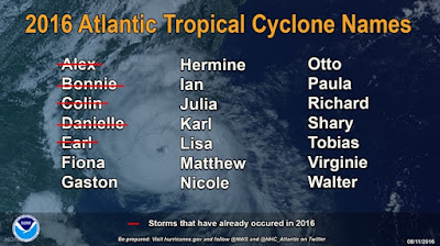
Five named storms (Alex, Bonnie, Colin, Danielle, and Earl) have formed in the Atlantic basin to date. Alex, which formed last January, and Earl became hurricanes. Four storms to date have made landfall, including Bonnie in South Carolina, Connie in western Florida, Danielle in eastern Mexico, and Earl in Belize and Mexico.
Preparedness for Tropical Storm and Hurricane Landfalls:
It only takes one storm hitting an area to cause a disaster, regardless of the overall activity. Therefore, residents, businesses, and government agencies of coastal and near-coastal regions are urged to prepare every hurricane season regardless of this, or any other, seasonal outlook.
Predicting where and when hurricanes will strike is related to daily weather patterns, which are not reliably predictable weeks or months in advance. Therefore, it is currently not possible to accurately predict the number or intensity of landfalling hurricanes at these extended ranges, or whether a particular locality will be impacted by a hurricane this season.
More info:
- Climate Prediction Center - Atlantic Hurricane Outlook
- 2016 Atlantic Hurricane Season
- NHC (National Hurricane Center) Marine Forecasts & Analyses
- National Hurricane Center: http://www.nhc.noaa.gov/
- Hurricane Response: http://oceanservice.noaa.gov/hazards/hurricanes/
- JohnTheCrowd | Sailing News: 2016 Atlantic Hurricane Season, NOAA Outlook, Preparedness (videos) 15 June 2016
more about sailing below (@ web version link below for mobile)
Follow @johnthecrowd


